SLU news

Field work is on, after Covid-19 lockdown

Published: 29 June 2021
Field technicians in Kenya

Healthy, functioning ecosystems are a prerequisite for human health and well-being. In the drylands of East Africa, pastoralist and agro-pastoralist communities are highly reliant on ecosystem services for their livelihoods. In Drylands Transform (an SLU led project), we investigate the interlinkages between land health, livestock-based livelihoods, human well-being and land governance mechanisms to contribute to transformative change and sustainable development of the socio-ecological system in the drylands of East Africa.

Last June 5, the United Nations launched the UN Decade on Ecosystem Restoration. The vision of the decade is  ‘a world where – for the health and well-being of all life on Earth and that of future generations – we have restored the relationship between humans and nature, by increasing the area of healthy ecosystems and by putting a stop to their loss, fragmentation and degradation’.

As part of the new #GenerationRestoration movement, Drylands Transform will generate scientific evidence and gather traditional knowledge on the benefits and implementation of rangeland restoration in the East African drylands to guide restoration initiatives and contribute to scaling landscape restoration globally.

An essential step to be able to investigate the interlinkages between ecosystem and human health is to collect data on the ground. This is exactly what we are doing at the moment!

Using the Land Degradation Serveillance Framework (LDSF)

We will be using the Land Degradation Surveillance Framework to provide a biophysical baseline at the landscape level. The Land Degradation Surveillance Framework (LDSF) is a comprehensive methodology for assessing soil and land health. World Agroforestry (ICRAF) developed the LDSF about 20 years ago in response to the need for indicator frameworks to measure and monitor soil and land health in a systematic, quantifiable, efficient and replicable way across landscapes.

The LDSF provides a consistent set of indicators and field protocols to assess soil and land health. Indicators measured with the LDSF include vegetation cover and structure, tree, shrub and grass species diversity, current and historical land use, soil properties (soil organic carbon, total nitrogen, infiltration capacity, texture, etc.) and soil erosion prevalence.

Data collection in the field follows a hierarchical sampling design with 4 nested spatial scales: Sites (100 km2) > clusters (1 km2) > plots (1000 m2) > subplots (100 m2).

LDSF sampling design

Description of the LDSF sampling design 

We were planning to start the LDSF fieldwork campaign by the end of March, but we had to postpone it after President Uhuru’s announcement of the cessation of movement into and out to Nairobi and neighbouring counties on March 26th due to the spike in Covid-19 infections. We finally started fieldwork in the Chepareria site in May, after the lift in the cessation of movement.

LDSF sampling procedures

Field observations are made at the plot and sub-plot level (i.e., across 160 plots and 640 subplots per site). In each subplot, we a) collect soil samples (both top- and subsoil) using an auger and record auger depth restrictions; b) measure the size of all trees and shrubs and identify them at the species level, c) record signs of visible soil erosion and classify it  (rill, gully or sheet erosion); and d) assess herbaceous and woody cover using ratings.  At the plot level, we describe and record basic plot characteristics, including plot center-point coordinates, altitude, slope, landform and topographic position, vegetation structure, dominant land use, land ownership, etc. Soil infiltration capacity is measured in 3 out of 10 plots per cluster. We also conduct detailed herbaceous vegetation measurements in two perpendicular transects per plot (N-S and E-W). 

LDSF sites

In Drylands Transform we will work in 4 LDSF sites within the Karamoja cluster, in the cross-boundary area between Uganda and Kenya. 

These sites provide variation in both livelihood strategies and climate. The two southernmost sites – Chepararia, in West Pokot County (Kenya) and Matany, in Napak District (Uganda) – are dominated by agro-pastoralist communities, whereas the two northernmost, more arid, sites – Rupa, in Moroto District (Uganda), and Lokiriama-Lorengkipi, in Turkana County (Kenya) – are dominated by pastoralists.

Map of the field sites in  Drylands Transform

Location of the four LDSF sites that will be sampled in Drylands Transform.

We expect to find differences between several of the indicators that we measure with the LDSF – from soil properties to vegetation structure and composition. Such differences will be likely starker between drier vs less drier sites. Predominant land use and land management practices will also vary among sites, as we could observe during the reconnaissance trip. We expect to find within-site variation as well.

Soil sample analysis

Soil samples are sent to World Agroforestry’s (ICRAF) Soil-Plant Spectral Diagnostics Laboratory in Nairobi, where they are pre-processed and analysed using mid-infrared (MIR) spectroscopy to predict key soil properties such as soil organic carbon (SOC), total nitrogen, pH, texture, and base cations. ICRAF’s Soil-Plant Spectral Diagnostics Laboratory is leading advances in soil spectroscopy and hosts the largest systematic, georeferenced library of soil infrared spectra in the world. We are very excited to contribute to this effort and to expanding ICRAF’s soil spectral library with data collected through Drylands Transform!

Systematic indicator framework

Why are systematic indicator frameworks such as the LDSF so valuable?

Systematic field surveys like the LDSF allow for cross-site analysis. Some of the applications of the LDSF include understanding the variability of environmental indicators across diverse landscapes, establishing a biophysical baseline, assessing the linkages between key indicators, better understanding drivers of land degradation, and tracking and designing land management and restoration interventions.

Over the last two decades, the LDSF has been applied in more than 300 sites across the global tropics. The LDSF database, which is hosted within the ICRAF-CIFOR Spatial Data Science and Applied Learning Lab, is currently one of the largest land health databases globally, with more than 30,000 observations.

Data from this global network of LDSF sites is used together with remote sensing data to create predictive maps of soil and land health indicators, for example soil organic carbon or erosion prevalence, at multiple spatial scales using machine learning algorithms. Such maps can then be used to track processes of land degradation and restoration over time, or to prioritize restoration interventions, among others. Data collected through Drylands Transform will both contribute to and benefit from the LDSF global network of sites.

Predictive maps within LDSF

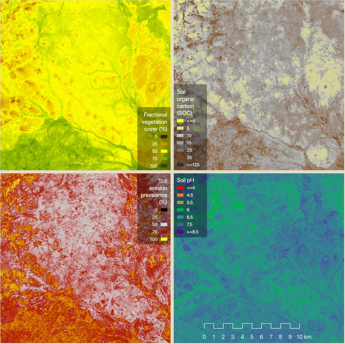
Examples of predictive maps of four land and soil health indicators (fractional vegetation cover, soil organic carbon, soil erosion prevalence and soil pH) produced based on the data from the global LDSF network of sites and remote sensing data.

References to similar work

Vågen, Winowiecki, 2019. Predicting the Spatial Distribution and Severity of Soil Erosion in the Global Tropics using Remote Sensing. Remote Sens. 11, 1800. https://doi.org/10.3390/rs11151800 

Vågen, T.-G., Winowiecki, L.A., Tondoh, J.E., Desta, L.T., Gumbricht, T., 2016. Mapping of soil properties and land degradation risk in Africa using MODIS reflectance. Geoderma 263, 216–225.

“I was surprised to find out that most of the plots under cultivation that we sampled had been converted to cropland quite recently (during the past 1 to 5 years). I think the communities in this site were predominantly pastoralists in the past and they are rapidly shifting towards agro-pastoralism. Much of the land we sampled was communal land, but in many cases, this land has been enclosed into small plots managed by individual families. This is very different from other rangeland areas in Kenya where I have worked in the past, and I believe it is an indicator of a shift towards agro-pastoralism that is occurring.” said John Thiong’o Maina, lead LDSF field technician.

Generating evidence for decision making

The data and evidence generated using the LDSF is valuable for farmers, pastoralists and extensionists, project managers and national and district level decision-makers. This data will also be used together with household survey data to understand the links between land health and human health across the four study sites.

"Rangeland condition was fair in Chepareria site, except in severely eroded patches. We found perennial grass species like Bothriochloa insculpta and Cynodon dactylon that are indicators of degraded land that is recovering. Enclosed sites had more decreasers (perennial grass species), which is an indicator of good rangeland condition. In contrast, areas with serious erosion were dominated by increasers (annual grasses and forbs)." said John Musembi Kimeu, Rangeland Taxonomy field technician.

The value of the LDSF data

This evidence is critical to guide and design sustainable land management practices and restoration interventions that benefit people and the environment, and to support holistic decision-making around land health. Stakeholders at local, regional and global scales will be able to interact with the LDSF data in platforms and engagement workshops, which will function as a tool for scientific synthesis and as a concrete method for the translation of empirical results into policy-relevant pathways towards a sustainable dryland transformation in East Africa.

Facts:

Logotype for the project Drylands Transform

Drylands Transform

Drylands Transform is a 4-year research project funded by Formas that started up during the Covid-19 pandemic in October 2020. It includes an interdisciplinary research team representing SLU and seven other universities and international organisations from Sweden, Kenya and Uganda. 

Visit the website for Drylands Transform.


LDSF responsible in Drylands Transform

Aida Bargues Tobella, Postdoctor
Department of Forest Ecology and Management, SLU
aida.bargues.tobella@slu.se, +46907868346

Leigh Ann Winowiecki, Leader of Land Health Decisions
World Agroforestry, ICRAF
l.a.winowiecki@cgiar.org

Stephen Mureithi, Dr., Lecturer
Department of Land Resource Management and Agricultural Technology
University of Nairobi, Kenya
stemureithi@uonbi.ac.ke, +254 203592736-9

Vagen, Tor-Gunnar, Geoinformatics Senior Scientist, Head of CIFOR-ICRAF SPACIAL (Spatial Data Science and Applied Learning Lab)
World Agroforestry, ICRAF
t.vagen@cgiar.org