Contact
Visit our Contact page to find contact information for the Software Development and Maintenance unit.

El-Reg is a mobile app for Android and iOS used by the Department of Aquatic Resources while surveying fish stocks in Sweden’s waterways. The survey technique is electrofishing, where submerged direct electrical current flow is used to stun fish long enough for their capture and measurement.
A fishing inventory is made at a given location. El-Reg supports the registration of the inventory name and its location with the help of map services where a user can choose an existing site or create and limit a new one.
Fish and other aquatic life are registered with species, length and weight. The app provides quality control and validation checks to notify the user of possible input errors and missing values. Checking this at source offers much higher data quality compared to previous paper based inventories. Having species name lists and location name lists in a common source provides for a much more homogenous data set despite many individual users, which makes it much easier to analyse El-Reg data and integrate it to other sources.
As well as the biological inventory, the app allows for the registration of several environmental attributes at the location such as water temperature and water level.
The inventory at a location is transferred in its entirety to a central database when connectivity is available. The app itself is designed for full function in offline mode as the availability of an Internet connection still varies much out in the field. All received inventories are subject to a final quality control of an appointed curator at SLU before being uploaded to the Swedish national database for electrofishing data (SERS).

Location planning in El-Reg.
1/7

Choosing an existing location via the map.
2/7

Survey planning in El-Reg.
3/7

Catch inventory listing in El-Reg.
4/7

Length distribution graph for a species.
5/7

Transect measurement in El-Reg.
6/7

Registration of aquatic vegetation.
7/7
Mobile application for Android and iOS (App) available from Google Play and App Store respectively.
SQLite internal database.
Map services with data from the Swedish Mapping, Cadastral and Land Registration Authority.
Microsoft SQL Server database.
ASP.NET REST API.
The app is developed in Microsoft’s cross platform framework .NET MAUI.
Programming language is .NET C#.
The app’s internal database uses SQLite.
The central collection database and reference data provided utilise Microsoft SQL Server.
OAuth is used for authentication.
The ArcGIS .NET runtime and data from the Swedish Mapping, Cadastral and Land Registration Authority are used for map services.
REST APIs are developed using Microsoft ASP.NET.
The Department of Aquatic Resources owns El-Reg.
Anders Kinnerbäck at the Intitute of Freshwater Research is the system administrator and part of the maintenance team.
El-Reg has been developed by the Software Development and Maintenance unit. The development project included client side representatives and two developers for approximately one year. Development is mainly in Visual Studio which as well as a PC requires a MAC as a build server for iOS. The release is in a pilot phase with a complete release expected in 2024.
A maintenance team including developers and client side representatives continue to work with further development, adaptations and life cycle management so that El-Reg continues to meet the clients business needs. El-Reg is part of the maintenance object FO Aqua led by Ellika Custhag.
The system includes test environments for the developers and the client side. Processes include automatic builds and tests via a build server.
Regular maintenance meetings are held by the team. Further development is periodic with releases as required. Regular maintenance tasks are performed according to a plan.
The unit developes several mobile apps. Parts of the software architecture are common across all and successful solutions for one app soon become beneficial for others.
As well as surveying for research and monitoring purposes, inventory data in the Swedish national database for electrofishing data is used extensively by town and regional councils. For example as support in decision making processes such as building permission and planning applications.
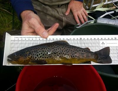
A trout being measured during an electrofishing survey. Photo: Magnus Kokkin, SLU
It is the regional councils and their contractors who carry out most electrofishing surveying today. It’s an established goal that these organisations and their staff will use El-Reg for their surveys. The app’s structure is therefore kept simple, clear and structured, in order to encourage the transition by providing a small learning step for new and existing surveyors.
Approximately 3000 locations are surveyed by electrofishing per year.
Visit our Contact page to find contact information for the Software Development and Maintenance unit.
Institute of Freshwater Research, Department of Aquatic Resources.
Read more about the Swedish national database for electrofishing data (SERS).